
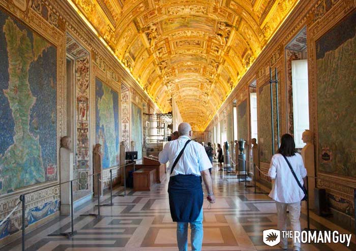
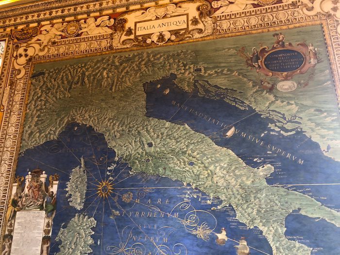
Of the many galleries in the Vatican, the Gallery of the Maps is often a crowd favorite. Displaying maps from all over the world created by Roman topographers during the 16th century, you can get a glimpse of what they thought the world looked like centuries ago. In this guide, we cover what you need to know about the Vatican Gallery of Maps before you visit.
Pro Tip: Planning your visit to the Vatican in Rome? Bookmark this post in your browser so you can easily find it when you’re in the city. See our comprehensive guide to Vatican City for more planning resources, our top Vatican tours for a memorable trip, and how to visit the Vatican.
Vatican Gallery of Maps Guide
As one of the holiest spaces in the world, many visitors travel to the Vatican for religious purposes. However, you don’t need to be religious to appreciate the incredible collections and works of art held in the Vatican Museums.
By far one of the most over-the-top as far as decoration goes, the Gallery of Maps is literally a gigantic mural with frescoes on both sides of maps depicting Italy. Pope Gregory XIII, also known as the calendar pope, commissioned this room to be painted so he could accurately study the lands in which he lived and the surrounding areas.
The pope is probably most known for giving us the Gregorian calendar, which fixed the errors of the Julian calendar, created by Julius Caesar 1,500 years earlier. The Gallery of Maps provides a scientific approach to some of the museum’s most interesting artwork.
As you prepare for your Vatican Museums visit, you might also want to check out our ultra-comprehensive list of what to see at the Vatican written by a licensed Vatican guide! In this guide, find out more about the gallery’s history and what to see. Here’s what we’ll cover:
- History of the Gallery of Maps
- What to see in the Gallery of Maps
- Restoration of the Gallery of Maps
- Gallery of Maps Facts
- Vatican Tours with Gallery of Maps
Not ready to book a tour? See if a Vatican tour is worth it.
History of the Gallery of Maps

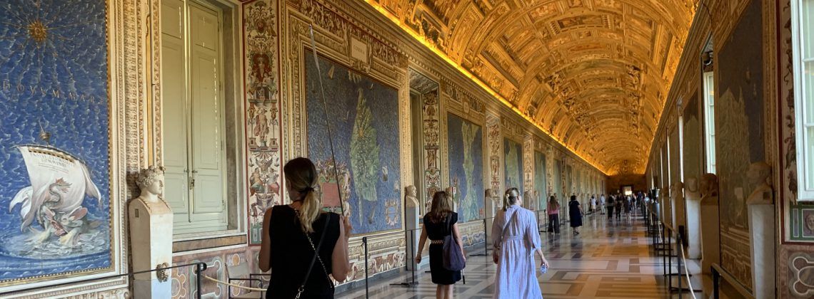
As you approach the Sistine Chapel, you’ll be led through a series of hallways and galleries. One of the most impressive galleries you’ll visit on this stroll is the Gallery of Maps. It consists of 40 frescoes of maps, detailing the Italian regions and papal properties that existed during the time of Pope Gregory XIII.
The frescoes were created by Ignazio Danti between 1580 and 1585. Pope Gregory XIII had good reason to commission Danti for this task, as Danti had already built himself quite a portfolio by this time.
Before designing the frescoes for the Gallery of Maps in the Vatican Museums, he had served as a mathematics professor in Bologna. And before that, Danti designed the Sala della Carte Geografiche in the Palazzo Vecchio in Florence.
What To See in the Gallery of Maps

The frescoed maps in the gallery show the entirety of the Italian peninsula including additional areas like Corsica and Sardinia. As you walk toward the Sistine Chapel, you’ll find lands on the Tyhrennian coast on the left and lands on the Adriatic coast on the right.
Each of the frescoes features a different region of Italy, with the region’s major city specifically pinpointed. You’ll also find that the frescoes highlight important battles in Italy that occurred in these regions, such as the Battle of Lepanto, the Siege of Malta, and more.
Are the Maps in the Gallery of Maps Accurate?
Interestingly, Pope Gregory XIII had these designed so that he could explore his peninsula without having to leave his home. Clearly, it’s tough to say that the maps are completely accurate.
One of the heads of restoration of the Gallery of Maps, however, has said that the contents of the maps at present are accurate for the most part. What the artists didn’t know, though, they chose to omit.
The Grotesques
Walking down this gallery, you’ll notice between each windowsill there’s a bizarre painting style depicting vines, demon-like heads, and strange children.
This painting style was called grotesque and was quite popular as decoration in the mid-16th century. The term comes from the Italian word grotta meaning “cave”.
At the beginning of the 16th century, artists like Raphael discovered ancient Roman frescoes in the area, which was Nero’s Golden House. This particular style had a huge impact on these artists, including Raphael.
Around the beginning of the 18th century, this decorative style fell completely out of fashion and that’s where today’s common meaning of the word “grotesque” comes from.
The Ceiling
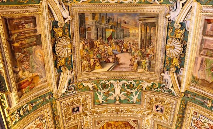
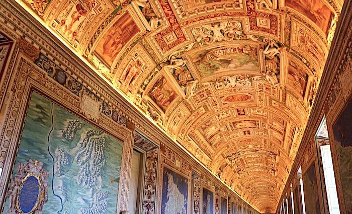
Imagine having to paint a 393-foot (120 meters) long ceiling and decorate it with stucco and gold leaf. That’s exactly what Ignazio Danti set out to do in 1580 together with artists Cesare Nebbia and Girolamo Muziano.
In three short years, they were able to finish not only the ceiling but even the side frescos. The ceiling is a mixture of saints, martyrs, apostles, and other important figures in Christianity.
When you look up, you’ll notice that the order of the paintings was meant to be viewed from the other direction, since the frescoes will be upside down to you.
What is even more remarkable is that the figures in the ceiling frescoes can be linked directly to the geographical positioning of the maps on either side.
Map of Sicily
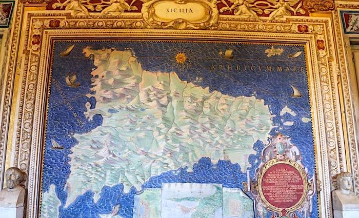
Many Italian-Americans can trace their lineage back to Sicily. When you look at the map, you’ll see all the major cities of this bountiful island. You’ll also see beautiful Taormina and the neighboring and still active Volcano Etna—it even shows some lava coming out of it on the map.
Many people will walk past and never notice an extremely strange detail about the map: All of the cities are upside down! That’s because when Sicily was being painted, the pope asked that everything be arranged according to what it looked like as if you were looking at it from Rome.
Map of Lazio
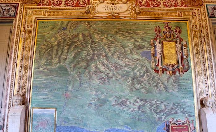
Lazio, or Latium in Latin, is the region surrounding Rome, the capital. In this map, you can see the entire region with a blow-up of the city of Rome itself in the bottom-hand corner. There are a few monuments that you can see there, which are still familiar to us today.
The most interesting one is St. Peter’s Basilica, which was still being constructed at the time. If you look closely, you’ll notice that a square hasn’t yet been built with the huge colonnade. That will be built by Bernini, but not for another 50 years!
Vatican Radio Station
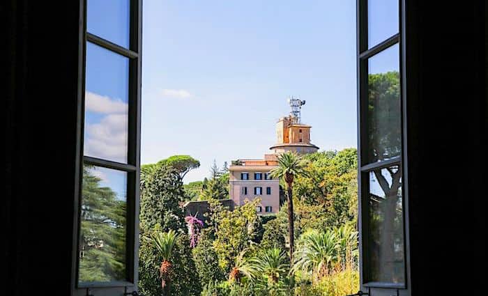
Midway down this gallery, on your right-hand side, you’ll see a set of windows that go from the floor to the ceiling. Take a look outside and you’ll not only get a great view of the Vatican Gardens, but you’ll also see a huge tower in the distance.
This is Radio Vaticana, the official radio of the Vatican State. Radio Vaticana was set up back in 1931 by Guglielmo Marconi. Today, the radio station broadcasts in 47 languages and is still maintained by the Jesuit order.
Restoration of the Gallery of Maps
These enormous yet delicate frescoes have been on display for nearly 500 years. Over the centuries, the maps have deteriorated due to moisture, dust, and overall poor maintenance.
The damage became so significant at some points, with stains and even material erosion, that visitors believed the maps presented geographic inaccuracies. Many Vatican Museums visitors would even ignore Danti’s topographical works and rush to the Sistine Chapel, with no concern for the Gallery of Maps because of the damage.
In 2011, the Vatican decided to restore this precious gallery and turned to the Patrons of the Arts in the Vatican Museums to fund a full restoration. During this meticulous maintenance project, the art restorers would lay special paper over the maps to absorb yellow glue from a previous failed restoration project.
From there, they were able to remove some of the stains and restore the maps to the beautiful masterpieces they were designed to be. You’ll find the Gallery of Maps near the Gallery of the Candelabra and Gallery of Tapestries.
Gallery of Maps Facts
- The Gallery of Maps stretches as long as a football field.
- If you look at the map of Sicily, you’ll notice that all of the cities are upside-down on the map. That’s because they made the map according to how it would look if you were seeing it from Rome.
- The Gallery of Maps is the world’s largest series of painted maps.
- The most recent restoration of the maps cost about $2.3 million.
- The current calendar we use today is named after Pope Gregory XIII (the pope who arranged for the design of this gallery), which brought about the idea of leap years.
Vatican Tours with Gallery of Maps
Supposedly, if you stand in front of each art piece for one minute in the Vatican Museums, it would take you 12 years to see everything. How incredible is that! While it’s certainly possible to visit the museums on your own, I highly recommend you join a tour guide.
Not only will a tour guide get you skip-the-line access, they’ll also guide you through the Vatican Museums quickly. Your guide will get you in and out before you go into overload without missing anything important.
Best of all, you’ll hear all the intriguing stories and history that make this museum and its collections so fascinating. It’s an added layer that will make your Vatican visit all the more meaningful.
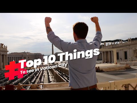
There are lots of Vatican tour options to suit your interests and schedule, compare our best Vatican tours. In most of our Vatican tours, you’ll see the Gallery of Maps up close, so check them out and reserve your spot! See the video below for the top things to see at the Vatican—the Gallery of Tapestries is featured at number five and you’ll get a preview of this beautiful space.
Not ready to book a tour? Find out if a Vatican tour is worth it.
Here’s Where To Stay in Italy’s Most Popular Destinations
Rome, Florence, Venice, Amalfi Coast, and Capri


")